Dugi Rat Riviera - Climate

Zalazak sunca  Riviera Dugi Rat

Riviera Dugi Rat - Climate

The following charts show yearly weather trends with information on monthly weather averages and extremes.


Dugi Rat Center - Printed Map

Dugi Rat - Temperature

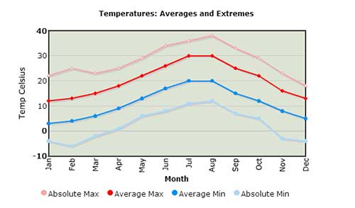
The chart below plots the average high and low temperature for each month of the year. It also shows the maximum and minimum recorded temperatures.

Dugi Rat Center - Printed Map

Dugi Rat - Precipiation

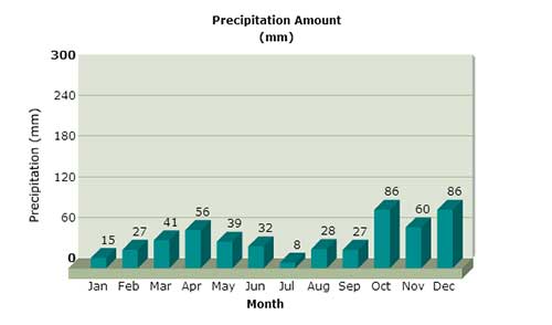
The chart below plots the average monthly precipitation amount.


Dugi Rat Center - Printed Map

Dugi Rat - Rainy days

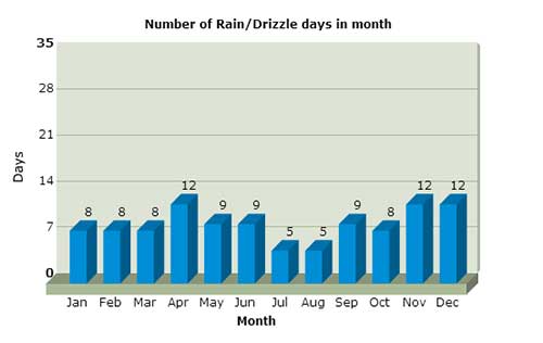
The chart below plots the average number of days in any month that you can expect to see rain falling.

Dugi Rat Center - Printed Map

Dugi Rat - Snow days

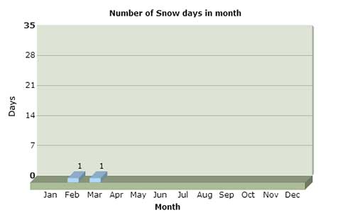
The chart below plots the average number of days in any month that you can expect to see snow falling.


Dugi Rat Center - Printed Map

Dugi Rat - Wind speed

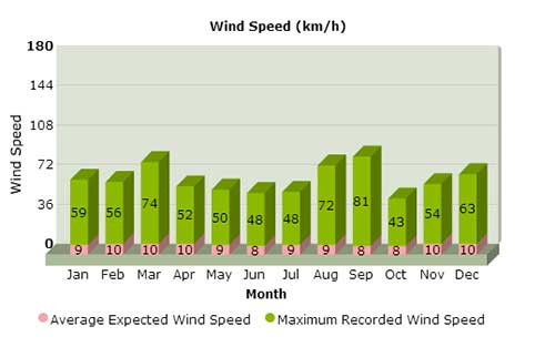
The chart below plots the average daily wind speed you can expect for any month. It also shows the maximum recorded sustained wind speed for each month.

HISTORICAL MONTHLY AVERAGES FOR AUGUST

The information presented below gives detailed historical monthly average weather conditions along with exceptional weather occurrences. To maintain relevance to current weather trends the displayed information has been calculated using data collected over the past two decades. The climate profile is taken from closest available data source to Split.

Throughout the month of August daytime temperatures will generally reach highs of around 30°C that's about 87°F. At night the average minimum temperature drops down to around 20°C, that's 67°F.
In recent times the highest recorded temperature in August has been 38°C that's 100°F, with the lowest recorded temperature 12°C, about 54°F.
The average daily relative humidity for August is around 49%.
The Heat Index is a measure of how hot it feels when relative humidity is added to actual air temperature. From this a comfort level is calculated providing categories on how heat conditions might adversely affect someone.
Comfort Levels:Given average maximum temperatures and humidity levels caution is advised. Fatigue is possible with prolonged exposure and/or physical activity for those in high risk groups of possible heat disorders
The average monthly amount of precipitation has been recorded at around 28 mm, that's 1 inches. Throughout the month you can expect to see rain or drizzle falling on 5 days of the month.
We calculate sunshine hours per day using our past forecast data. For August expect the sun to shine for an average of 13 hours per day. This represents the average number of hours in the daytime that the sun is visible and not obscured by cloud e.g. the average number of hours the sun is actually out and shining. Note we calculate hours of sunshine per day using our past forecast data, not observation data, thus it is an estimate and not actual.
The average daily wind speed in August has been around 9 km/h, that’s the equivalent to about 5 mph, or 5 knots. In recent years the maximum sustained wind speed has reached 72 km/h, that’s the equivalent of around 45 mph, or 39 knots.
On average the month of August is not affected by foggy conditions.

RENTERS CORNER


DATA PROTECTION (GDPR)


ACCESS TO INFORMATION

QUICK GALLERY

  • Fishermans in Dugi Rat
  • Fishermans in Dugi Rat
  • Fishermans in Dugi Rat
  • Fishermans in Dugi Rat
  • Fishermans in Dugi Rat
  • Fishermans in Dugi Rat
  • Fishermans in Dugi Rat
  • Fishermans in Dugi Rat